Typhoon "Kang Sen" will pass over Hainan Island in the south of Xisha Islands and there will be heavy rain.
Cctv newsAccording to the website of the Central Meteorological Observatory, it is predicted that Typhoon Kang Sen will move westward at a speed of 10-15 kilometers per hour, with little change or slight increase in intensity, and will pass over the south of Xisha Islands. From 08: 00 on the 10th to 08: 00 on the 11th, there will be 6-7 gale in the western South China Sea and Xisha Islands, and there will be heavy rain in most parts of Hainan Island, Xisha Islands and zhongsha islands, with heavy rain (100-180mm) in the southern part of Hainan Island and parts of Xisha Islands.
Yesterday, there was heavy rain or rainstorm in parts of Jilin, Liaoning and Jiangsu.
From 08: 00 yesterday to 6: 00 today, heavy rain or rainstorm occurred in parts of central Jilin, north-central and southeastern Liaoning, southeastern Jiangsu, northern Zhejiang, western Fujian, central Guangxi, southeastern Sichuan, western Guizhou and northern Yunnan, and heavy rain occurred in Nantong, Jiangsu (100-184 mm, with a maximum hourly rainfall of 90-105 mm); 8 ~ 9 thunderstorms and strong winds occurred in southeastern Inner Mongolia, central and southern Jilin, central and northern Liaoning and western Liaoning.
This morning, fog with visibility less than 1 km appeared in eastern and southern Hebei, eastern Beijing, most of Tianjin, western Liaoning, southern Shandong, southern Henan, northern Anhui, and central and northern Jiangsu. The visibility in some of these areas was less than 200 meters.
"Kang Sen" will pass over the southern part of Xisha Islands.
The center of the 13th typhoon "Kang Sen" (a strong tropical storm) this year is located at 5 o’clock this morning (10th) in the central South China Sea about 165km southeast of Yongxing Island in Xisha, Sansha City, Hainan Province. The maximum wind force near the center is 10 (28m/s), and the lowest pressure in the center is 982 hectopascals.
It is estimated that "Kang Sen" will move westward at a speed of 10-15km/h, with little change or slight increase in intensity, and will pass through the south of Xisha Islands before approaching the coastal area in central Vietnam. From 08: 00 on the 10th to 08: 00 on the 11th, there will be 6-7 winds in the western South China Sea, Xisha Islands, zhongsha islands, Nansha Islands and the southern coast of Hainan Island, among which the winds in the southern Xisha Islands and the western zhongsha islands are 8-9, and the winds in the nearby waters passing by the Kang Sen Center are 10-11, with gusts of 12-13. There will be heavy rains in most parts of Hainan Island, Xisha Islands and zhongsha islands, with heavy rains (100-180 mm) in southern Hainan Island and parts of Xisha Islands. The Central Meteorological Observatory continued to issue a blue typhoon warning at 06: 00 on September 10th (see Figure 1).
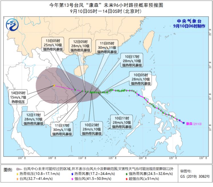
Fig. 1 Probability forecast chart of the next 96 hours for Typhoon No.13 "Kang Sen".
"Candu" will approach the eastern coast of Taiwan Province Island.
The center of the 14th typhoon "Candu" (super typhoon level) this year is located at 5 o’clock this morning (10th) in the northwest Pacific Ocean about 910 kilometers east-south of Yilan County, Taiwan Province, China. The maximum wind force near the center is 16 (55 m/s), and the lowest pressure in the center is 930 hectopascals.
It is estimated that Candu will move to the north-northwest at a speed of about 20 kilometers per hour, and its intensity will gradually weaken, and it will gradually approach the eastern coast of Taiwan Province Island. On the 12th, it will land or brush the northeast coast of Taiwan Province Island during the day, and then move into the southern sea of the East China Sea, and gradually approach the northeast coast of Zhejiang (see Figure 2).
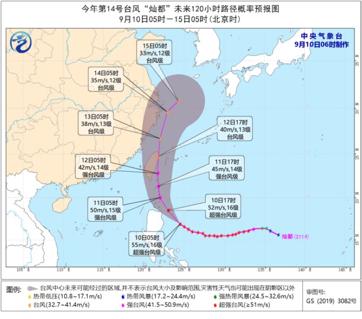
Fig. 2 The path probability forecast chart of Typhoon Candu No.14 in the next 120 hours.
Specific forecast for the next three days
From 08: 00 on September 10 to 08: 00 on September 11, there were small to moderate rains in parts of northeastern Inner Mongolia, northern and eastern Heilongjiang, central and eastern Jilin, most of Liaoning, eastern Jiangnan, southern Tibet, western and southern Sichuan, northern Yunnan and most of southern China, and heavy rains in southern Liaoning, eastern and southern Hainan. There are 6 ~ 8 winds in parts of northern and eastern Xinjiang, western Inner Mongolia and western Gansu (see Figure 3).
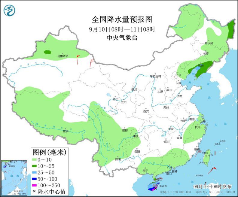
Figure 3 National Precipitation Forecast Chart (08: 00 September 10-08: 00 September 11)
From 08: 00 on September 11th to 08: 00 on September 12th, there was moderate to heavy rain (25-35 mm) in eastern Liaoning, eastern Sichuan Basin, western Chongqing, eastern coastal areas of Zhejiang, most of Hainan Island and Taiwan Province Island, and there was heavy rain in some areas, among which there was heavy rain (100-200 mm) in the southeast of Taiwan Province Island. There are 4 ~ 5 winds in some areas along the Tianshan Mountains in Xinjiang (see Figure 4).
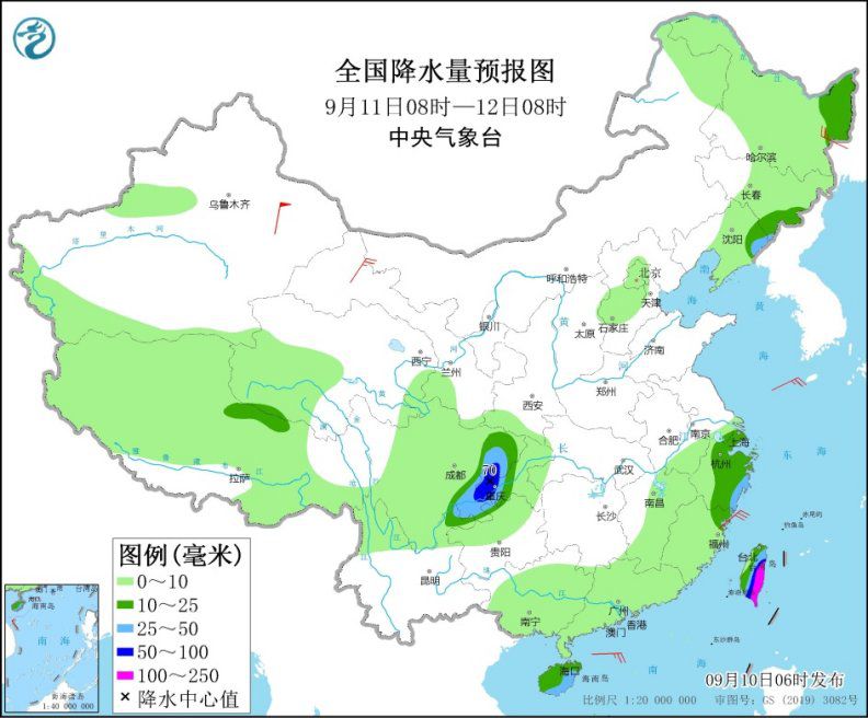
Figure 4 National Precipitation Forecast Chart (08: 00 on September 11th-08: 00 on September 12th)
From 08: 00 on September 12 to 08: 00 on September 13, there were moderate to heavy rains in parts of central and eastern Inner Mongolia, the eastern coast of Jiangnan, the eastern Sichuan Basin and Taiwan Province Island, among which there were heavy rains or heavy rains (100-240 mm) in parts of eastern Zhejiang and Taiwan Province Island. There are 7 ~ 8 strong winds in the eastern coastal areas of Zhejiang (see Figure 5).
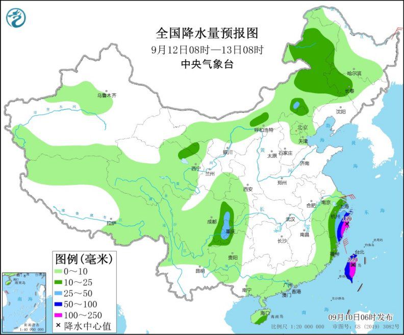
Figure 5 National Precipitation Forecast Chart (08: 00 on September 12th-08: 00 on September 13th)